Thunderstorms
Topics available on this page:
- Cumulonimbus
- Cumulus
- Maturity stage
- Dissipation stage
- Deviating from a Cumulonimbus cell
- Hazard mitigation
- Accidents and incidents
- Electrical Discharge
- Effects on the aircraft
- Effects on the aircraft - video
- Rays in the area of aerodrome movement
- Lightning Strike
- Accidents and incidents
Cumulonimbus
The storm of Cumulunimbus is also a meteorological phenomenon that can offer danger to the flight.

Storm Cumulunimbus over the Pacific Ocean. Photo: Santiago Borja
During a thunderstorm, phenomena such as strong winds, hail, hail, lightning, turbulence, tornadoes, ice formation and heavy rain can be seen.
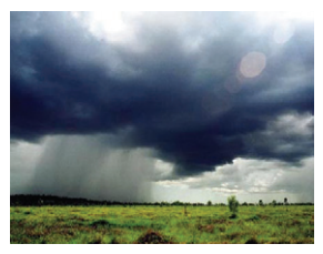
Source: http://www.bom.gov.au/aviation/data/education/flying-tropics.pdf
All of these phenomena are associated with a Cumulonimbus cloud (CB).
Cumulunimbus (CB) clouds , also known as storm clouds, can produce all forms of precipitation, including large raindrops, hailstones, heavy bursts, lightning and violent bursts.
Inside, there are intense ascending and descending currents and, due to them, one can find hail almost all its extension, as well as, in its entrono the gusts of wind can reach values of approximately 100 km / h, to a distance up to 12km beyond the cloud.
Clouds Cumuloninbus (CB) occur in all states throughout the year. However, they are more common in the warmer months in the late afternoon.
CB clouds can produce solid precipitation (hail or hail), lightning, thunder and turbulence.
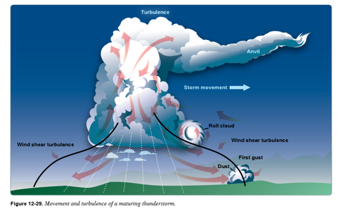
Source: FAA Handbooks Manual
Precipitation in the form of blows generally does not exceed 20 minutes in duration.
This type of cloud has great vertical development, much larger than all other types of clouds.
Read more about the different types of clouds in Highlights .
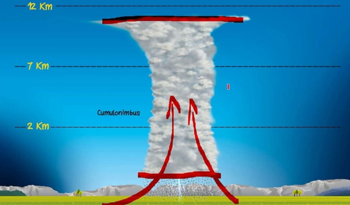
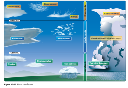
Source: FAA Handbooks Manual
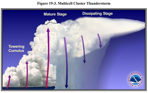
Source: FAA Advisory Circular AC 00-6B
They are dense and powerful clouds with immense vertical dimension. Its bases are between 700 and 1,500 m, with tops reaching 24 and 35 km in height, being the average between 9 and 12 km.

Note 5-1
Cloud group information in METAR refers to the height of the cloud base relative to the aerodrome.
For the development of a CB cloud, there are three essential ingredients: moisture, instability and upward currents.
The life cycle of a CB cloud goes through three consecutive stages, whose durability (from 20 to 180 minutes) and intensity will depend on the factors that gave rise to the phenomenon.

Note 5-2
Because a CB cloud can form and dissipate in less than 45 min, it is possible that at the time of pre-flight (briefing), minutes earlier, it does not appear on the weather radar. This requires more attention from the crew, who must be prepared to be surprised.
To avoid surprises, it is important to check the weather information available during the flight planning phase.
Cloudiness of the Cumulunimbus (CB) type cloud may be indicated in the Predicted Upper Air Chart (PROG Chart).
See an example letter from PROG at 6:00 PM (UTC). In particular, there is information about the presence of cloudiness with built-in CB in the vicinity of the Brasília-Goiânia route.
Click on the image to enlarge.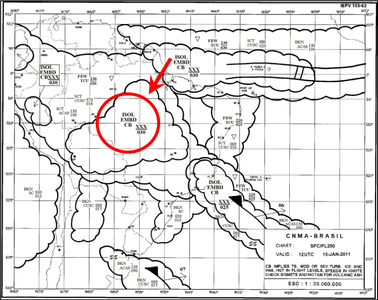
In this other example, the area marked in red indicates prediction of embedded Cumulonimbus cloud cells located near the state of Mato Grosso do Sul, following the line of a semi-stationary front.
Click on the image to enlarge.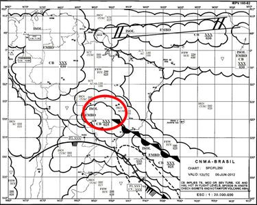
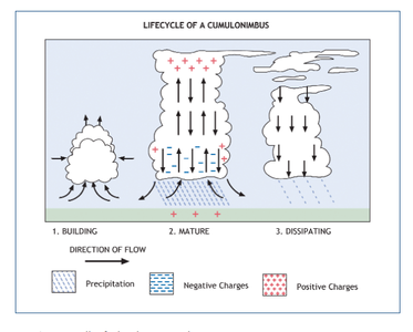
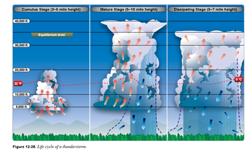
There are 3 stages in the life cycle of a Cumulunimbus cloud: cumulus stage, maturity stage, dissipation stage.
Cumulus
Although not all Cumulus clouds grow enough to produce a storm, the first phase of a thunderstorm's life cycle is called "Cumulus."
At this stage, the upward currents predominate from the lower levels, passing through the interior of the cloud and reaching many hundreds of feet above the top. The cumulus cloud begins to develop vertically, due to the ascending air currents that dominate the entire cloud, transforming into a CUMULUS TOWER.
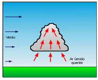
Maturity stage
It is the most dangerous phase for aviation due to the intensity of the associated phenomena.
Ascending (vertical) currents can reach speeds near 40 knots.
At its top, winds at high levels (horizontally) begin to form their "anvil or hair", sometimes reaching up to 100 miles in the wind.
The top exhibits horizontal expansion due to the upper winds, resembling the shape of a blacksmith's anvil, and is formed by ice crystals.
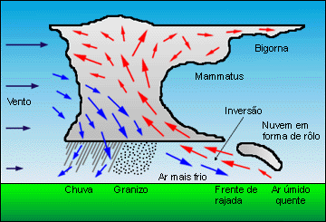
At that point, the cloud must already be reaching the average height of 25,000 feet, and as precipitation intensifies, the downward currents will strengthen.
At this stage, they may experience high winds and wind sharp intense ( Wind Shear ), dangerous for landing and takeoff operations.
Dissipation stage
It is a phase where the downward currents intensify due to the gradual increase of precipitation and the upward currents weaken.
During this phase, strong winds from the upper levels transform the top of the cloud into a large Cirrus mass in the form of an anvil, generating a lateral expansion of the cloud.
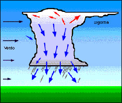
Among the severe weather conditions associated with a CB cloud, we can highlight turbulence, hail, wind gusts, electric shocks and ice formation.
To mitigate the danger of turbulence caused by the CB cloud, the pilot usually decides to fly over the top, or bypassing it from the left (in the southern hemisphere) or from the right (in the northern hemisphere).
Deviating from a Cumulonimbus cell

Note 5-3
One way to minimize the risks caused by the severe turbulence of a Cumulonimbus cellis to maintain a vertical separation of 5,000 feet and 20NM lateral separation of such clouds.
Note 5-4
In addition to making deviations from cumulonimbus cloud formations, another efficient way to manage risk is to return to the starting aerodrome or proceed to an alternate aerodrome. Good flight planning and route study may assist in the identification of alternative aerodromes in the area within range and range of the aircraft.
During en-route flight, severe CB formations can be concealed by small stratified clouds. These function as if forming a "curtain" on the windshield, hiding the cumulonimbus clouds that are miles ahead of the aircraft.

Note 5-5
The topography of the region may contribute to the generation of new active and isolated storm cells, the downdrafts peculiar to cumulonimbus clouds. Depending on the atmospheric circulations, the topography of the region can trigger conditions to lift the air.
Source: Eurocontrol Publications
Source: FAA Handbooks and Manuals

Note 5-6
Flight in the vicinity of the CB may pose a high risk due to severe turbulence. Aircraft may undergo vertical accelerations of more than 8 meters per square second when in severe turbulence.
Note 5-7
A meteorological information that can assist the pilot in identifying the CB cloud presence along the route is SIGMET, a code that identifies the information issued by a meteorological watchdog and related to the existence, actual or expected, of phenomena specified routes, which may affect the safety of aircraft operations.
A Convective Severe Weather System (STSC) was developed by DECEA to provide the localization and monitoring of convective cells in their most active stage, cumulonimbus clouds (CB), which, due to their vertical development, have a significant impact on air space and the operation of the aircraft in flight.
In order to meet the Air Traffic Management and Control systems, each identified convective cell is registered and its associated characteristics such as geographic location, time and origin source (Radar and / or DEA - Atmospheric Electric Discharges) are identified.
Click on the image to enlarge.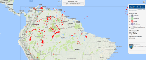
To view the prevailing position of the convective cells, go to: https://www.redemet.aer.mil.br/stsc/public/producto
Equipment installed on aircraft for the detection of storms (storm-scope type ) or meteorological radars can identify convective cells.
Access RBAC 135
Hazard mitigation
The action of strong upward and downward air currents can affect the stability of the aircraft. In an attempt to maintain control, the pilot needs to be aware of the decisions that can be made so as not to compromise flight safety.
If the pilot is surprised and can not divert from a Cumulonimbus cloud present in the route of his flight plan, he should take some care:
- Secure all objects that are loose;
- Make position message (AIREP);
- Perform radar scanning for better cloud assessment;
- Turn off the radio and remove the headphones;
- Maintain the path of penetration and never try to return;
- Maintain flight altitude based on artificial horizon;
Even having taken all these precautions, the pilot may be surprised by some breakdowns in radome, windshield, and other aircraft damage.

Source: Infomoney
In the flight planning phase, the presence of Cumulonimbus cells at the departure aerodrome, along the route or at the destination aerodrome can be identified through the consultation of meteorological bulletins.
Accidents and incidents
The Cumulunimbus clouds were mentioned in the investigation reports of the following accidents / incidents
- A-515 / CENIPA / 2016
- A-520 / CENIPA / 2016
- A - 519 / CENIPA / 2016
- A - 507 / CENIPA / 2015
- A-052 / CENIPA / 2014
- A-560 / CENIPA / 2014
- A - 040 / CENIPA / 2013
- A-029 / CENIPA / 2013
- A-050 / CENIPA / 2013
- A-064 / CENIPA / 2013
- A-122 / CENIPA / 2012
- A-001 / CENIPA / 2011
CENIPA reports available at http://prevencao.potter.ne # mce_temp_url # t.br/relatorio/page/1
- A321, en-route, Gimpo South Korea, 2006
- A321, en-route, Vienna Austria, 2003
Electrical Discharge
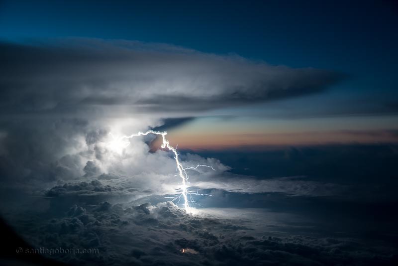
Source: http://www.santiagoborja.com/myportfolio/lightning-strike/
High intensity electrical discharge can occur internally in a cloud, between clouds, and between cloud and soil.
The electric current, in the house of hundreds of amps, can cause high temperatures, high pressures along its trajectory and create electromagnetic fields.
These discharges are caused by the friction between the particles in the cloud.
They can be of great extension (a few kilometers) and of great intensity (peaks of current intensity above a kilogram).
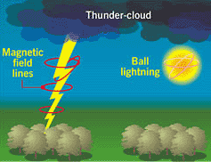
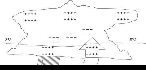
Globally, intra-cloud discharges account for about 70% of the total number of electrical discharges.
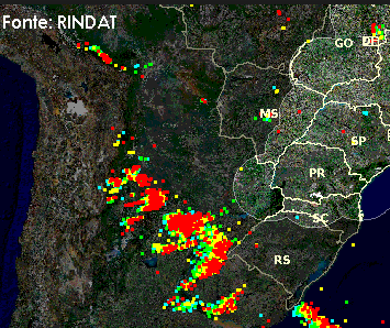
Brazil records a series of electrical discharges daily.
Effects on the aircraft
The effects of atmospheric electrical discharges on an in-flight aircraft are somewhat different than the effects on surface (ground) targets, largely due to the lack of grounding, which prevents the current from causing its full potential damage.
The main risks involved when an aircraft is struck by lightning are: ignition of the fuel vapor of engines, faults and damages in electro / electronic equipment, including communication, navigation, electrical, control and actuator systems, mechanical damage, among others.
As the aircraft fuselage is made of metal, which causes the effect of the beam to produce an effect called the " Faraday Cage ", which is the potential electric distribution evenly over the metal surface, the damaging effects of the discharges to the internal components become smaller.
In addition, aircraft have the static wingtip and stabilizer (vertical and horizontal) dampers that help eliminate static charges accumulated over a flight, thereby minimizing the effects of lightning on aircraft.
Effects on the aircraft - video
Although the number of accidents involving electric discharges has reduced considerably in recent decades, this issue becomes relevant in more modern aircraft due to the increasing use of generally lighter composite materials and digital systems in critical functions. Due to their lower electrical conductivity the composite materials reduce the protection usually obtained with aluminum, material previously used.
Some lightning strikes caused damage to the aircraft structure. The regions of the aircraft most prone to entry and exit of electric discharges vary from aircraft to aircraft and depend essentially on their geometry, material used and operational factors.

Note 5-8
The hazards of turbulence, wind shear, and ice formation associated with Cumulonimbus cloudsare much greater than the threat of lightning. Therefore, it is recommended to stay at least 20 nautical miles displaced from any Cumulonimbus cloud.
If flying in the vicinity of Cumulonimbus cloudsand lightning strikes are identified near the aircraft, it is advisable to refer to the guidelines in the aircraft manual for action to be taken in the event of a fire.
The National Transportation Safety Board (NTSB) investigated several lightning events that led to the total loss of hydraulic systems or were responsible for structural damage that significantly affected aircraft controls. As a result of the study, it recommended that the Federal Aviation Administration (FAA) study the technical feasibility of presenting, through the WARP system or other means, real-time lightning data on the flight controller displays at the ARTCC and TRACON facilities:
Therefore, the NTSB recommends that the FAA study the technical feasibility of presenting, through the use of the WARP system or other means, real-time total lightning data on controller displays at both ARTCC and TRACON facilities, and, if feasible, time total lightning data on controller displays and in associated weather products for current and future display systems.
the NTSB recommends that the FAA incorporate real-time total lightning data into the products supplied to pilots through the FIS-B data link.
Therefore, the National Transportation Safety Board makes the following recommendations to the Federal Aviation Administration: Study the technical feasibility of presenting, through the use of the weather and radar processor system or other means, real-time total lightning data on controller displays at both air route traffic control centers and terminal radar approach control facilities, and, if feasible, incorporate real-time total lightning data on controller displays and in associated weather products for current and future display systems. (A-12-18)
To the extent practicable, incorporate direct center weather service unit briefings on new weather-related air traffic control equipment and information services into controller training. (A-12-19) Incorporate real-time total lightning data into the products supplied to pilots through the flight information services - broadcast data link. (A-12-20)
(Source: National Transportation Safety Board Washington, DC Safety Recommendation May 18, 2012. In reply refer to: A-12-18 through -20 ).

Source: Oilandgaspeople.com
In October 2013, the Oil and Gas People institute did some research on a phenomenon known as Triggered Lightning .
The investigations investigated lightning events on North Sea helicopters operating offshore during the winter season at the North Sea oil and gas fields.
Source: Wilkinson, JM, Wells, H., Field, PR and Agnew, P. (2013), Investigation and prediction of helicopter-triggered lightning over the North Sea. Apps, 20: 94-106 .
The study report related electrical discharges on helicopters with Cumulonimbus clouds that occur during winter periods, where large masses of cold air act on relatively warm waters.
The study looked at cases where helicopters were struck by lightning as they made their way from the airport to the offshore platforms .
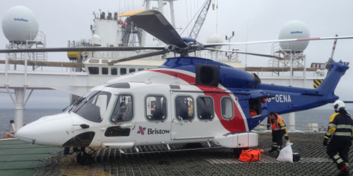
Source: Oilandgaspeople.com
Using the information in this report and the forecast data from the Met Office Unified Model , the UK Civil Aviation Authority (CAA) has developed a lightning prediction test model that allows helicopter operators to plan flights, considering the regions of high risk. The information can be transmitted directly to companies operating helicopters in the North Sea.
Lightning in the area of aerodrome movement
Electrical shocks occurring during storms can be potentially dangerous if there is an incidence in the area of aerodrome movement, since lightning poses a hazard to ground staff (ramp crews).
As they are generally working in flat and open areas, these employees are more exposed to lightning hazards.
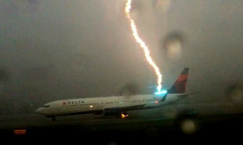
Source: Panrotas
A recent case occurred on July 22, 2017, at the Florida airport, where an operator during a pushback procedure received Lightning strike discharge that crossed the aircraft fuselage.
Lightning strike
The Transportation Research Board , through the Airport Cooperative Research Program, has produced a report ( ACRP 8 ) which provides means to assess the operational benefits that lightning detection systems can generate to the operation of aerodromes.
The report emphasized the importance of coordinating meteorological information with lightning monitoring networks for use as warning systems against lightning at airports:
Page 51 of ACRP 8:
"Summary and Recommendations:
(...)
Of particular importance is the consideration and evaluation of remote sensing observations, most likely meteorological radars and total lightning systems, the replacements for EFMs in operational lightning detection and warning systems. Warning systems based solely on routine surface observations, numerical models, and remote sensing may be able to remove any need for lightning-speci fi c detection hardware to be installed or maintained at individual airports. If successful, this transformation should result in lower costs to airports and airlines, while preserving or improving lightning hazard identi fi cation. Airport-speci fic studies should also be directed at evaluating the performance of currently available lightning systems, optimizing the warning criteria for these systems, and quantifying the potential tradeoff between safety and ef fi ciency. "
In ACRP Report 131 - A Guidebook for Safety Risk Management for Airports , a guide with guidance to aerodrome operators on potential airport risks, section 9.5 provides guidance for aerodrome operators to cancel or postpone activities when the lightning detection / prediction system indicates the probability of occurrence of this phenomenon within a radius of 2 miles from the aerodrome.
In Brazil, ANAC has established the following obligation in RBAC 153 for aerodrome operators, when the occurrence of lightning strikes during the fuel supply and transfer operation of the aircraft is identified.
Access the RBAC 153
Accidents and incidents
Lightning strikes were mentioned in the investigation reports of the following accidents / incidents
- I-011 / CENIPA / 2010
CENIPA report available at http: // prevention # mce_temp_url # .potter.net.br / report / page / 1
- SB20, vicinity Sumburgh, UK 2014
- A332, Perth WA Australia, 2014
- AAIB Report No: 1/2005. Report on the accident to Sikorsky S-76A +, G-BJVX near the Leman 49/26 Foxtrot platform in the North Sea on 16 July 2002.
- AS3B, en-route, northern North Sea UK, 2008
- D228, near Bodø Norway, 2003
- Kato Air - 603, Bodoe, Norway, Avisa Nordland, 2003.
- E145, vicinity Manchester UK, 2001
- B752, Girona Spain, 1999
- AAIB Report No: 2/1997. Report on the accident to Aerospatiale AS332L Super Puma, G-TIGK, in North Sea south west of Brae Alpha Platform on 19 January 1995.
- Nurnberger Flugdienst - NFD, Mulheim, IFCAO Adrep Summary 2/90 (# 32), 1988
- Iran Air Force, Madrid, NTSB AAR-78-12, 1976.
- National Airlines - 508, Puerto Inca, 1971
- Pan American World Airlens, Elkton Maryland, USA, NTSB-DCA64A003, 1963.
- Air Inter, Lyon, ICAO Accident Digest No. 15 - Volume II, Circular 78-AN / 66 (179-185), 1963.
Did you find errors in this content ? Send email to meteorologia@anac.gov.br to report.