Fog
Topics available on this page:
- Fog
- Horizontal visibility
- Space Disorientation
- Visual Range Runway (RVR)
- Low visibility operation
- Landing in low visibility conditions at Guarulhos Airport - SP
- Watch: landing in low visibility
- Letter AGMC
- Accidents and incidents
Fog
Fog is a phenomenon whose physical constitution resembles that of a cloud, differing only in location because it occurs near the surface. It is formed by extremely small water droplets that float in the air, reducing the horizontal visibility to less than 1 thousand meters.
Fog forms when the air temperature is low enough to make the water vapor liquid. For this to occur, it is necessary that the environment is very humid, with large amount of droplets of water suspended in the air.
This phenomenon usually occurs in mountainous regions, where altitude acts in the reduction of temperatures and in the interception of humid air masses coming from other localities, and in areas close to watercourses, such as rivers and mainly lakes. During the day, there is the emission of large amount of moisture in the form of vapor, which condenses at night, forming denser fogs in the early hours of the morning.
At temperatures above 0ºC, the fog can only exist with very high relative humidity.
In the vertical direction, the fog causes reduction of visibility, being able, in some occasions, totally obscure the sky.
Favorable conditions for fog formation are weak surface winds, high relative humidity (close to or equal to 100%) and abundant condensation cores.
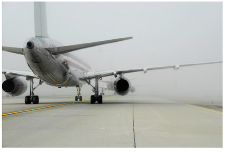
Source: http://www.bom.gov.au/aviation/data/education/fog.pdf
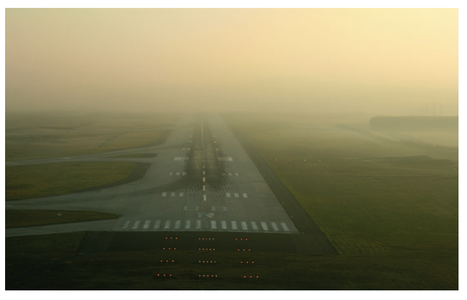
Source: Source: http://www.bom.gov.au/aviation/data/education/fog.pdf
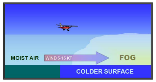
Source: https://www.faa.gov/documentLibrary/media/Advisory_Circular/AC_00-6B.pdf
In addition to reducing horizontal visibility to less than 1 m, fogs can also cause a considerable reduction in vertical visibility, preventing a ground observer from seeing the sky or clouds above the fog. When this occurs, the fog is classified as an obscured sky fog (invisible sky).
By dramatically reducing visibility, the fog impacts landing and takeoff operations at aerodromes.
Restriction caused by fog can occur in oblique visibility and horizontal visibility.
The oblique visibility is that experienced by a pilot when in flight or in the approach glide path for instrument landing.
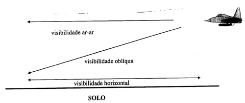
Horizontal Visibility
The horizontal visibility is able to spot and identify prominent objects during the day, not illuminated, and during the night, prominent objects illuminated according to the atmospheric conditions and expressed in units of distance.
Information on horizontal visibility is disseminated through the METAR Code.
In this type of meteorological message, the horizontal visibility value is reported in increments of 50m at 50m to 800m, and from 100m at 100m to 5,000m. From there, in increments of 1,000m in 1,000m.
The surface visibility will be considered "zero" when it is less than 50m.
METAR SBSP 202300Z 16004KT 110V200 3600 BR SCT002 OVC005 14/12 Q1024
At aerodromes that have meteorological stations, visibility is measured by a visibility and present time sensor, installed near the runway.
At low-visibility aerodromes, the sensor can be installed at various points along the runway and landing strip to increase accuracy and cover the entire airport area.


Note 1-1
If the aircraft is only approved to fly in visual conditions, the presence of strong fog makes the weather unfavorable to the flight for this equipment, as the visibility restriction may cause pilot disorientation - loss of direction and space.
During the flight without external references, the accelerations imposed on the pilot, due to the movement of the aircraft, can influence his perceptive references, leading him to believe that he is flying under certain conditions (level, inclined, with accelerations etc.) when, in reality, the aircraft may be in conditions totally different from those perceived.
In addition, the flight condition without external visual references, in which the pilot is not enabled, can set up a complex operation scenario, causing him to focus his attention more on an action, that is, on the visual search for the lane or other the maintenance of the pilot (control of the flight parameters and the navigation of the aircraft).
There are countless cases of failure, when a pilot tries to remain in visual condition flying under IMC conditions. In these cases, attention should be focused on the instruments on board (attitude indicator, altimeter, vertical speed indicator, etc.), are no longer monitored for precious seconds, just as the pilot is trying to seek external references.
Therefore, in order to avoid entering into flight conditions for which it is not enabled, when encountering cloud conditions that are incompatible with the visual flight, such as the strong fog, it is recommended that the pilot make the landing decision in alternate aerodromes, including the original one, for which he may return and wait until the flight conditions are adequate for the visual flight. The aircraft must have enough fuel for these possible route changes.
As required by ICA 100-12 (Air Rules and Air Traffic Services) during the flight preparation phase, it is the duty of the pilot-in-command to check the meteorological conditions of the aerodromes involved and the route to be flown.
Space Disorientation
In the 1950s, researchers from the University of Illinois (USA) conducted tests with 20 students, all with experience in visual flights, to identify how long a pilot with little or no in-flight training (IFR) could survive on a flight under conditions of bad weather and restricted visibility.
The students were placed in flight simulators and everyone, without exception, got into an abnormal attitude and eventually lost control of the aircraft.
According to the study, the performance of students only differed in one relevant aspect: the time elapsed until spatial disorientation. This range ranged from 480 to 20 seconds, indicating that pilots without IFR training in adverse weather conditions would have a mean life expectancy of 178 seconds.
In the 5th edition of the ANAC Safety Charter, guidelines were presented on risk management related to meteorological factors and practical measures to maintain control of the aircraft for a limited period of time in the case of a VFR flight that inadvertently enters IMC conditions .
The article provided guidance to assist the pilot operating VFR to keep his aircraft under proper control until appropriate visual references are retrieved.
Check here
Visual Range Runway (RVR)
In low-visibility aircraft operation, there are two important definitions.
- Decision height: height during the precision approach / landing at which a rush procedure should be initiated if the visual reference necessary to continue the approach has not been established.
- Visual Range Runway (RVR) , which indicates the distance in meters or feet in which the pilot of an aircraft in the center of the lane can see the markings of the lane or the lights that delineate the lane, or the line center, in low visibility conditions. The RVR along the track is determined by measurements obtained using instruments positioned near the track (aircraft touch zone, middle and end of the track) which, by comparing an emitted and received optical signal, allows the determination of the opacity of the atmosphere at the moment.
On days and nights with favorable conditions for fog occurrence, if the visibility restriction is below 2,000 meters, RVR information will be considered in the aerodromes that have equipment for their mediation.
This is the definition of RVR contained in Doc 9837 AN / 454 - Manual on Automatic Meteorological Observing Suspends at Aerodromes - International Civil Aviation Organization (ICAO), Charpter 2, Explanation of terms: Runway visual range (RVR). which the pilot of an aircraft on the center line of a runway can see the runway surface markings or the lights delineating the runway or identifying its center line (meter, m).
In the national documents, the definitions of RVR follow the same line as that defined by the ICAO.
The RVR is disclosed in the METAR code as follows:
Examples: SBGR 251000Z 08008KT 0500 R09L / P2000 R09R / 1100U R27R / 0500D R27L / M0050 FG OVC001 15/15 Q1022
R09L / P2000 (RVR on lane 09L, greater than 2,000 meters)
R09R / 1100U (RVR on runway 09R, 1,100 meters with a tendency to increase)
R27R / 0500D (RVR on runway 27R, 1,100 meters with a tendency to decrease)
R27L / M0050 (RVR on runway 27L, less than 50 meters)
ICAO determines how to use RVR through DOC 9328-NA / 908 - Manual of Runway Visual Range Observing and Reporting Practices
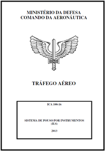
The FAA also has an RVR
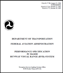
Read more about RVR at: https://www.faa.gov/about/office_org/headquarters_offices/ato/service_units/techops/navservices/lsg/rvr/
Low visibility operation
In addition to being important for landing and take-off operations, RVR is also an essential critical element in determining whether or not an aerodrome is operating in low visibility, in accordance with the parameters established by RBAC 153, and which procedures aerodrome needs to be adopted to ensure the safety of ground operations ( pushback , convoy and taxi of aircraft in low visibility conditions).
Access RBAC 153 - amendment 01
By the degree of sensitivity and importance, information about RVR can not be estimated. It needs to be measured. The sensor that records the value of the RVR is called a transmitter and is also installed near the headwaters in the lane range, usually along with the other weather sensors.
In a low-visibility operation, some instruments need to be used to ensure safety. One is the ILS (Instrument Landing System ) system , which is a system based on the transmission of radio signals that are received, processed and presented on the aircraft's on-board instruments.
The ILS approach is also called "Precision Approach" ( Precision Approach ) for having the Finder information on VHF ( Very High Frequency ), English localizer , which is located 1,000 ft after the opposite bedside at which performs approach and the Glide Slope antenna in UHF ( Ultra High Frequency ), providing information for alignment with the lane axis at the approach - "landing ramp" or "electronic landing ramp."
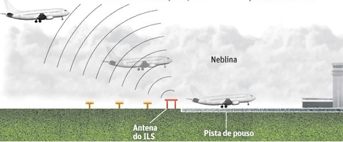

Three Operation Categories (CAT) are defined in low visibility conditions:
CAT I: Approach and precision landing by instruments with decision height of not less than 60m and visibility not less than 800m, or RVR not less than 550m;
CAT II: Approach and precision landing by instruments with decision height less than 60m and not less than 30m, and RVR not less than 350m;
CAT III A: Approach and precision landing by instruments with decision height less than 30m, or no decision height and RVR not less than 200m;
CAT III B: Approach and precision landing by instruments with decision height less than 15m, or without decision height and RVR between 200m and 50m;
CAT III C: Approach and precision landing through instruments with no decision height and no RVR limitations.
In addition to the RVR parameters, another difference between the CAT I, CAT II and CAT III operations is the possibility or not of the manual landing at the decision time. In CAT I and CAT II operations there are visual conditions that allow a manual landing at the decision time, whereas in CAT III operation an automatic landing system or a guidance system is required.

Note 1-2
In the case of an automatic landing (CAT III), although the system makes the fully automatic landing without pilot intervention, the pilot must continuously monitor the landing so that, if necessary, it can intervene immediately, ensuring safety the operation.
Landing in low visibility conditions at Guarulhos Airport - SP
In order to operate in the aforementioned operation categories (ILS CAT I, II or III), it is necessary that:
1) The aerodrome is equipped with the ILS system and certi fi ed;
2) The airport infrastructure is adequate for this type of operation, according to the parameters set forth in RBAC 154 ;
3) The aircraft is certified for this type of operation, and
4) The crew is trained through periodic in-flight training or flight simulator.
Watch: Landing in low visibility
In the case of Low Visibility Takeoff ( LVTO), the aerodrome must be equipped with a system that allows the determination of the deviation of the aircraft from the center of the runway (LOC -ILS, or MLS, or GLS / GNSS) and track lighting system for pilot orientation. In addition, the aircraft must be certified for this type of operation and the crew trained.
The low visibility take-off system shall provide side guidance information which, if followed by the pilot, shall keep the aircraft in the center of the runway during running on the runway, during acceleration to takeoff, or during deceleration to of an interrupted takeoff.
Highlights include the head-up display system (HUD) which, through a projection system, allows the pilot to have the external view through the front window at the same time.
In addition to the ILS system, another important instrument to ensure the safety of operations in fog conditions is the use of Route Letters (AGMC): ground motion charts.
These letters may indicate restricted areas, hot spots and specific routes.
One of the objectives of the publication of this information is to prevent the pilot's disorientation in a low visibility condition caused by fog.
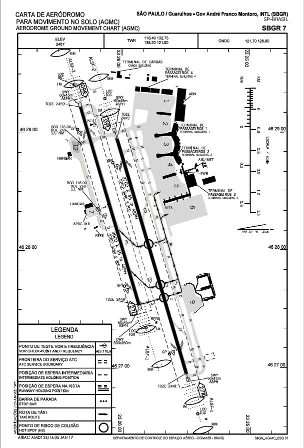
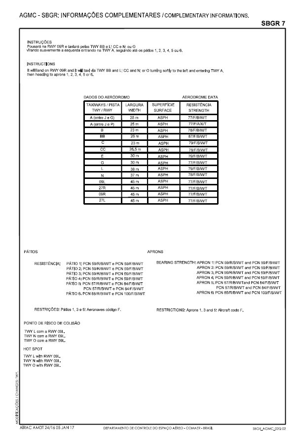
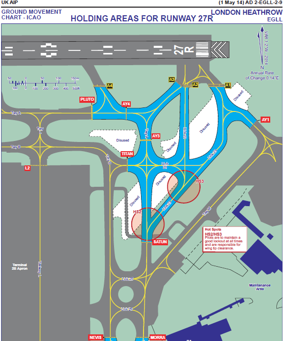
At the aerodromes where the operation occurs under low visibility conditions, a system of guidance and control of ground movement (SOCMS) shall be established by the aerodrome operator. This is a system consisting of aid and information for drivers and pilots on routes and places of action, and measures to ensure, in any part of the aerodrome movement area, an orderly and safe flow for vehicle and aircraft traffic on ground .
The quantity and location of the horizontal and vertical signs, lights and other facilities that make up the SOCMS must be adequate to the more restrictive visibility condition in which the aerodrome operates.
In some aerodromes, there are also ground radars. The use of radar allows the monitoring of the movement of aircraft and vehicles, which contributes to the prevention of runway incursion during the occurrence of fog.
Display of the ground radar and ILS system, EHAM TOWER, Schiphol Airport

Image: Wikimedia

Note 1-3
During the dissipation of a fog, although conditions of soil visibility improve, often a thick layer of clouds is formed covering the entire sky, the base of which may lie between 50 and 100 meters from the ground.
This meteorological condition can be potentially dangerous for operation of aircraft not approved for instrument flight (IFR) because the base of this layer of clouds will be very close to vegetation and other obstacles in the ground.
Note 1-4
In some situations of occurrence of stationary front, the presence of fog and cloudiness that restricts visibility can be verified in the post-frontal area.
This SIGWX card indicates the presence of a post-frontal fog.
Click on the image to enlarge.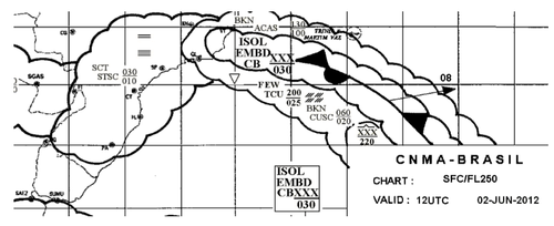
Source: www.rede # mce_temp_url # met.aer.mil.br
In the flight planning phase, information on the probability of occurrence of fog at the departure aerodrome, along the route or at the destination aerodrome, can be obtained by consulting weather reports.
Accidents and incidents
This phenomenon was mentioned in the investigation reports of the following accidents / incidents:
- A-163 / CENIPA / 2015
- A-043 / CENIPA / 2014
- A - 188 / CENIPA / 2013
- A - 113 / CENIPA / 2013
- A-098 / CENIPA / 2013
- A-024 / CENIPA / 2013
- A-169 / CENIPA / 2013
- A-092 / CENIPA / 2012
- A-42 / CENIPA / 2009
- A-005 / CENIPA / 2007
CENIPA reports available here:
- A320, Hiroshima Japan, 2015
- A333, Kathmandu Nepal, 2015
- A320, Jaipur India, 2014
- GLF3, Biggin Hill UK, 2014
- B738, Delhi India, 2014
- C501, vicinity Trier-Fohren Germany, 2014
- B738, Mangalore India, 2012
- C500, vicinity Santiago Spain, 2012
- T154, vicinity Smolensk Russian Federation, 2010
- DHC6, vicinity Oksibil Indonesia, 2009
- A343, Nairobi Kenya, 2008
- DC91 / B722, Detroit MI USA, 1990
- DC93 / B722, Madrid Spain, 1983
- B742 / B741, Tenerife Canary Islands Spain, 1977
*As notas que contém itens de regulamentos brasileiros não foram traduzidas para que a interpretação delas não seja diferente da interpretação pretendida.
**Notes containing items of Brazilian regulations have not been translated so that their interpretation is not different from the intended interpretation.
Did you find errors in this content ? Send email to meteorologia@anac.gov.br to report.